
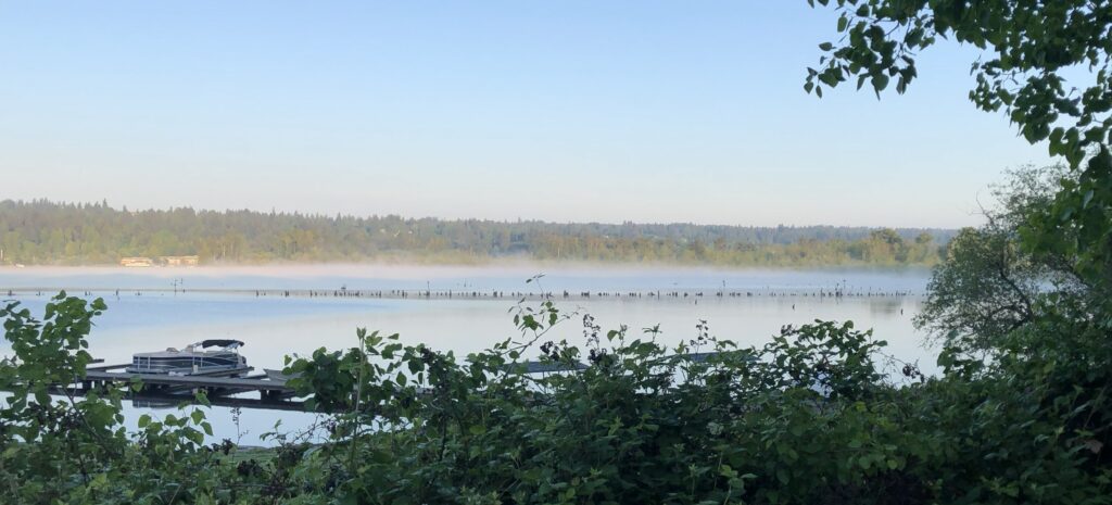
Fog often arises from a gentle mixing of air. Some of the air will be warmer and with more vapor, while other air is cooler and with less vapor. In wet areas near the ground, as well as over water, the vapor is often near saturation for its temperature (i.e., near 100% humidity). When near-saturated air of different temperatures mix, the resulting air can be super-saturated, that is, with excess vapor to produce a fog of droplets.
To see how this can work, consider the plot below. Here, circle B indicates a possible value of the temperature and vapor density. Vapor density is the total mass of vapor (if you could weigh it, say by condensing all of it) in a cubic meter of air. A value of 1 g/m3 means the vapor, if completely condensed, would be roughly a volume of water of the size of a sugar cube. Consider that this is the conditions of air above the lake and the nearby marshy ground the previous evening in the region near the fog in the above picture.
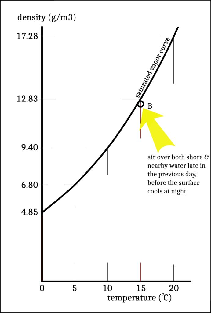
Anyway, notice that B is slightly below the curve marked “saturated vapor”. What this means is that air B has no droplets in it. But if the same air manages to somehow get above the curve, then it will tend to get some fog droplets. The value of B is reasonable for the air towards the end of a warm day like yesterday, before cooling began at night. Last night, like most nights, the ground cooled, so the air in contact with the ground would also cool, say to circle A in the plot below:
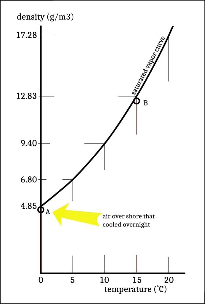
Why so much cooling in this case? The ground always radiates heat upwards, which cools the ground unless there is an equal amount of heat radiating downwards. But unlike a cloudy sky, a clear sky does not radiate much downwards. So, compared to a cloudy night, the ground cools down more on clear nights* thus also cooling the air touching the ground. As night progresses and the ground continues to cool, the air touching the ground cools much more than the air a little ways up. The ground also cools much more than the water. This cooler air is marked A on the plot.
Notice that the fog in the picture is near the shore. Here the air just off the ground is right next to the air right off the water. If air “A” from near the ground mixes with air “B” (either higher up or over the water), what is the resulting air mixture on our plot? See below.
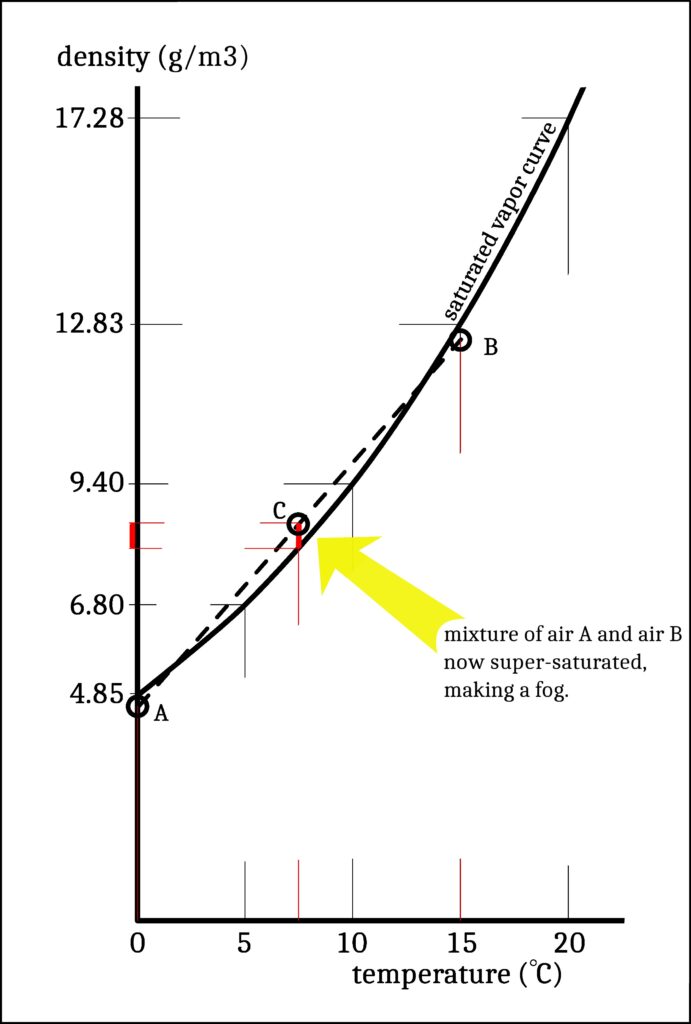
The mixture must be on a line between A and B, as sketched as a dashed line above. Say it is equally mixed, as at circle C. Notice that C, as well as most of the dashed “mixing line”, is above the saturated vapor curve. Hence, mixed air can easily produce droplets. The amount above the saturation line at C, marked in red, is about 0.5 grams of water per cubic meter. Half a gram isn’t much compared to the air. The air itself is over 1000 times heavier (about 1400 g per cubic meter), so indeed the 0.5 gram excess vapor (that will condense into droplets) is a very small component of the air. Condensed into one water drop, this half gram would be about half the volume of a sugar cube. Yet broken up into many fine droplets, this much water would form a fog. If the formed fog consists of very large cloud droplets, say 20 microns across, then each cubic centimeter of air would also have 130 droplets. A more typical size for the droplets would be nearly ten times smaller, a size at which that same cubic centimeter of air would have 1000 times more droplets (i.e., 130,000). That is a lot of droplets for such a tiny volume!
So, the above numbers tell us that even small deviations from the saturated vapor density line can have major visual effects. These values represent a rather thick mixing fog, probably much thicker than that shown in the photo above, but the same principles hold for other cases. For instance, on a cold day, circle B can represent the breath you exhale, in which case, it is even warmer. Drawing a similar dashed line from below 0 C (cold) to 35 C (your breath) could easily cross the saturated vapor curve, even if the outdoor relative humidity is low. So, your exhaled breath mixes with the cold outside air and becomes supersaturated. Your breath makes fog**. Fun times with cloud physics.
Note that the circle B could also saturate by merely cooling. This “path” to saturation might have also produced some of the fog in the picture. We call it radiation fog because it forms when the ground’s loss of heat by infrared radiation is enough to cool the neighboring air to a super-saturated condition. So, there are two main ways that air near the ground can cool to make fog. In general, both occur, but when one clearly dominates, we refer to it by that process–either a mixing fog or a radiation fog. In this case, I also noticed that the tufts of fog were moving very slowly off-shore, so it appeared to be air from over the ground (A) moving over the water and mixing with that air (B), in other words, a mixing fog. But radiation was also important as it drove the change from B to A.
As to why the air moved from ground to water, the air is pushed because it has higher pressure over land and thus produces offshore flow. What happens is that the relatively warmer air over the water rises up, and spills out over the land up higher, which then produces greater pressure at the ground and pushes air at the ground over the water, thus completing a cycle. Later in the day, the opposite flow (water-to-land) tends to happen as the land warms up more than the water. That case would be onshore flow.
–Jon
* The amount sketched above may be an overestimate of the cooling, but helps to illustrate the principle.
**If you purse your lips and pressurize the air before slowly releasing it, you can sometimes prevent the fog. Why? Upon release, the air is cooled. So, the mixed air bits are both cold and less likely to saturate.